This site uses affiliate links, meaning that if you make a purchase through our links, we may earn an affiliate commission.
Whether you like short and easy hikes or challenging trails, here is a downright list of the most scenic hikes in Bryce Canyon National Park where you are guaranteed to see breathtaking scenery.
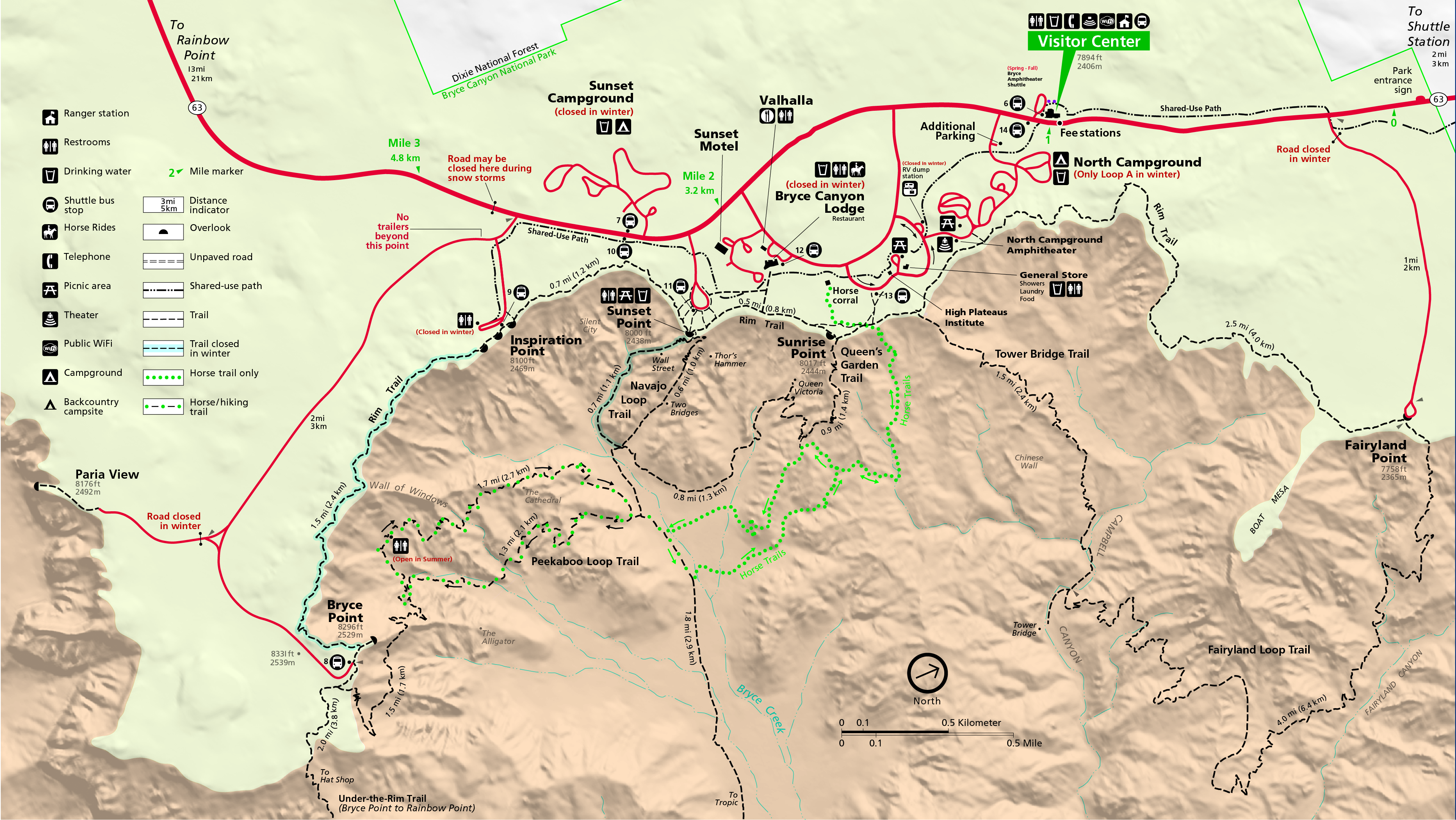
There are other things to do besides hiking the Bryce Canyon Trails! For a break from Bryce hiking trails, make sure to put Bryce Canyon Scenic Drive along epic viewpoints on your Bryce Canyon itinerary. This scenic drive will take you to some of the best viewpoints in Bryce Canyon National Park.
- 1. Bryce Canyon National Park At-A-Glance
- 2. Bryce Canyon Hiking Tips
- 3. Essential Gear for Hiking in Bryce Canyon National Park
- 4. 11 Most Scenic Hikes in Bryce Canyon You Need to Explore
-
- 4.1. Bryce Canyon Navajo Loop Trail - One of the Most Popular Hikes in Bryce Canyon
- 4.2. Queens Garden Trail - One of the Best Hikes in Bryce Canyon National Park to See Hoodoos Up Close
- 4.3. Tower Bridge Trail - One of the Bryce Canyon National Park Best Hikes to See Famous Hoodoos
- 4.4. Hat Shop Trail - Best Hiking in Bryce Canyon to See Unique Hoodoo Formations
- 4.5. Bristlecone Pine Trail - Best Bryce Canyon Hiking to See Bristlecone Pines
- 4.6. Sheep Creek and Swamp Canyon Loop Trail - The Best Trail to Avoid the Crowds
- 4.7. Fairyland Loop Trail - Hands down, one of the best trails in Bryce Canyon
- 4.8. Mossy Cave Trail - Fun Trail in Bryce Canyon to See a Waterfall
- 4.9. Peek-A-Boo Loop Trail - The Most Scenic Hike in Bryce Canyon National Park
- 4.10. Riggs Spring Loop Trail - One of the Best Hikes in Bryce Canyon National Park to Escape the Hustle and Bustle of Bryce Amphitheatre
- 4.11. Bryce Canyon Rim Trail - One of the Best Hikes to Catch the Views of the Amphitheatre
- 5. Intrepid's Tips for Most Scenic Hikes in Bryce Canyon
Bryce Canyon National Park At-A-Glance
Before diving into the most scenic hikes in Bryce Canyon, here are a few highlights to help you plan your trip to Bryce:
- Best Time to Visit Bryce Canyon National Park
Hands down, Bryce Canyon National Park is a great destination to visit at any time of the year.
I have visited Bryce Canyon so many times at different times of the year and I have to honestly say that it is an awesome place to see no matter what month you visit!
What you need to keep in mind is that Bryce Canyon National Park sits at a high elevation of 8,000 to 9,000 feet. With this being the case, the temperatures are much lower compared to any other National Parks in Utah.
So, no matter when you are visiting Bryce Canyon National Park, pack some warm clothes and dress in layers. Even in the summer, the evenings can be chilly.
- Where to Stay in or near Bryce Canyon National Park
Nothing beats staying inside the park! However, there is only one lodge, The Lodge at Bryce Canyon, available inside the park and accommodations are very limited. You should make reservations well ahead of your visit.
I have stayed at Best Western Ruby’s Inn numerous times and it is comfortable and convenient located only 1 mile from the entrance to the park. Also, if you are heading to Escalante National Monument, then this is a good place to spend the night since it is next to Scenic Byway 12. If you are flying into Bryce Canyon Airport, then the hotel offers a free transfer service from the airport to the property.
Another place that I am recommending is Best Western Plus Bryce Canyon Grand Hotel. It is also conveniently located right next to the entrance to Bryce Canyon National Park. The rooms are spacious, clean, and comfortable.
And finally, if you are traveling from Zion to Bryce Canyon, then my recommendation is to check out Best Western East Zion Thunderbird Lodge. It is conveniently located between Zion and Bryce in Mount Carmel. The rooms are a good size with comfy beds!
- How to Get to Bryce Canyon National Park
The closest major airports to Bryce Canyon National Park are in Las Vegas (LAS), Nevada, and Salt Lake City (SLC), Utah.
There are smaller airports in Cedar City (CDC), Utah, and St. George (SGU), Utah. I use Skyscanner to browse flights and find the best price.
If you fly into any of the airports around Bryce Canyon National Park, you will have to rent a car and then drive.
- How to Get Around in Bryce Canyon National Park
If you are visiting Bryce Canyon National Park during the high season (summer), then the best way to get around the park is by using Bryce Canyon Shuttle System. Now, the shuttle is not mandatory, however, it is highly recommended, since finding a parking spot could be very challenging.
All in all, whenever I visited during the winter months, I have to honestly say, that I never had any problems driving in the park (no traffic jams) or finding a parking spot. However, summertime is a different story altogether!
- Intrepid Scout’s Tip:
It costs $35 to enter the park. The entrance pass is good for 7 consecutive days. If you are visiting several national parks then make sure to get America the Beautiful National Park Pass. This $80 pass is valid for 12 months and gets you into all 400+ national park sites!
- Important: Always check for the latest road or trail closures and changes to shuttle routes or schedules. Check HERE.
Bryce Canyon Hiking Tips
- Elevations in Bryce Canyon National Park Park reach over 9,000 feet. Even mild exertion may leave you feeling completely out of breath, light-headed and nauseated.
- Keep in mind that all trails below the rim involve steep climbs out of the canyon.
- Stay on maintained trails. Do not wander off.
- If you are hiking in winter consider getting crampons and ski poles for extra grip and support
- Do not feed wildlife. First, they get used to being fed and consequently, they visit the campsites and parking lots looking for food. In addition, human food is not the best option for their diets. Lastly, they bite. Keep your food and your fingers to yourself.
Essential Gear for Hiking in Bryce Canyon National Park
- Appropriate footwear
Trail shoes are great; hiking boots are even better since they offer more support. You’ll want sturdy, comfortable hiking boots with solid traction. Don’t forget to break in your shoes before bringing them to Bryce Canyon National Park. Also, do not forget merino wool socks. They will keep your feet dry, and protect you from blisters.
- Plenty of water
Without enough water, your body’s muscles and organs simply cannot perform as well. Consuming too little water will not only make you thirsty but susceptible to hypothermia and altitude sickness. I have been using Yeti Rumbler 26 oz insulated, stainless steel bottle, and I am highly recommending it!
- Food
Food will help keep up energy and morale. I like RXBAR. It is a high-protein bar, gluten-free, and it is super yummy! Make sure to get a variety pack to keep it interesting.
- Rain gear and extra clothing
The weatherman is not always right. Be prepared for unannounced rain or a cold spell. Dress in layers. It will allow you to adjust to changing weather and activity levels. Two rules: avoid cotton (it keeps moisture close to your skin) and always carry a hat. I have had my North Face Women’s Osito Triclimate Jacket for years, and I love it. Also, I am highly recommending these Patagonia moisture-wicking hiking shirts and Patagonia warm fleece pullovers.
- First aid kit
Prepackaged first-aid kits for hikers are available at any outfitter.
- Knife
A knife or even better, a multi-purpose tool is always good to have. These enable you to cut strips of cloth into bandages, remove splinters, etc.
- Protect Yourself from the Sun
If you are hiking in the summer, keep in mind that many trails are unshaded, so it’s important to protect yourself from the sun. Sunscreen is essential, however, a lightweight long sleeve shirt is a must! My favorite are sun shirts by Columbia. Also, it is a good idea to wear lightweight long pants to protect yourself from the sun and bugs!
Wear sunglasses with UV protection. Sunglasses are an important part of your sun-protective wardrobe. When purchasing sunglasses, always look for lenses that offer UV protection.
A wide-brimmed hat is a simple and effective way to cover up your face and neck. When selecting a hat, choose one that has a wide brim, which will protect your ears, as well as your head and neck. Avoid baseball hats or straw hats with holes, as these are not as effective in protecting you outdoors.
- Apply an effective insect repellent
Insect repellent is an important step against mosquitoes and ticks that can spread diseases like West Nile and Lyme. When selecting an effective insect repellent, do not look at the brand names, but rather, look at the concentration of the active ingredients. Concentrations of DEET at 25 to 30% are the best to keep you protected.
- Daypack/backpack
You need something you can carry comfortably and has features designed to keep you hiking smartly. Don’t forget the rain cover; some packs come with one built-in. I have Osprey Daylite Daypack and it is perfect for day hiking.
- Camera!!!
Grand Teton National Park is a photographer’s dream! If you are like me, you will be taking hundreds, if not thousands, of photos. The scenery is just breathtaking and constantly changing. I have a Nikon COOLPIX P1000 Super Telephoto Camera that I bought a couple of years ago and I really like it.
- A spare battery for the camera
Make sure to have a spare battery for your camera. I think there is nothing more frustrating than knowing that you still have half a day ahead of you, yet your camera’s battery is gone.
- Tripod
If you are taking photos during the golden hour (shortly after sunrise or before sunset) when the light is softer, a tripod is essential for long exposure shots. Also, I like a tripod since it gives me more stability when taking close-ups of wildlife. I have Manfrotto Befree Live Carbon Fiber Tripod with Fluid Head. It is only 3.0 pounds and it fits nicely in my backpack.
- Binoculars!
If your camera does not have a good zoom, then binoculars are a must.
- Trash Bag
This will make sure that the trail will stay beautiful for generations to come. A zip-lock bag is a great option as well for keeping the trash you pick up along the trail separate from the rest of your gear.
11 Most Scenic Hikes in Bryce Canyon You Need to Explore
Bryce Canyon Navajo Loop Trail - One of the Most Popular Hikes in Bryce Canyon

Map of Bryce Canyon Navajo Loop Trail / Image Source: NPS / Most Scenic Hikes in Bryce Canyon
- Roundtrip Distance: 1.3 miles (loop), however, this Bryce Canyon National Park hike is not a loop in winter when the Wall Street section of the trail is closed.
- Trail Location: Sunset Point
- Time: 1-2 hours
- Elevation Change: 550 feet
- Difficulty: Moderate
Of all Bryce Canyon hikes, Navajo Loop Trail is one of the most popular hikes in Bryce Canyon National Park!
The hoodoo formations that are along the trail, such as Wall Street, Twin Bridges, and Thor’s Hammer are Bryce Canyon’s must-see iconic sights.
How to Get to Navajo Loop Trail in Bryce Canyon National Park
Navajo Loop Trailhead is located at Sunset Point.
Sunset Point is located about 2.5 miles from the Visitor Center.
In order to get to Sunset Point Bryce Canyon, you can take the shuttle, which I am highly recommending if you are visiting during the summer months.
Otherwise, from the Visitor Center take the main road and proceed for about 2.5 miles until you reach the junction marked with a sign pointing towards Sunset Point. Turn left at the junction and drive for no more than 0.3 miles until you reach the parking area.
What You Need to Know About Navajo Loop Trail
What you need to know about Navajo Loop Trail, is that it is considered one of the moderate hikes in Bryce Canyon National Park. The reason for this classification is the steep ascent from the canyon.
However, if you feel like giving your heart, lungs, and legs a little challenge, I encourage you to take this trail.

Navajo Loop Trailhead in Bryce Canyon National Park / Most Scenic Hikes in Bryce Canyon
The one thing that I can tell you, is that you will not be disappointed with this hike.
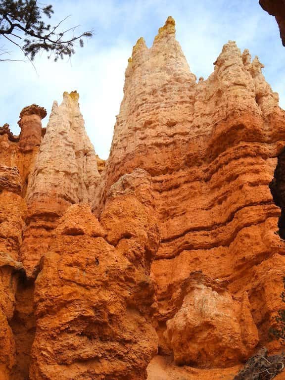
The trail travels down into the amphitheater and you get up close to the most famous hoodoos in Bryce Canyon: Wall Street, Twin Bridges, and Thor’s Hammer.
You can do Navajo Loop Trail any way you want it. You can start on the eastern or western side of the loop.
However, keep in mind that the climb back up along the eastern side is a bit easier compared to the western side of the trail. The elevation changes at a more gradual rate on the eastern side. Either way, you will have a few zig-zags to conquer and eventually, you will be back at the top of the rim.
So, here we go! Let’s start on the eastern side of the trail known as Wall Street.
The trail begins with a series of switchbacks that lead you down a cool ravine and all the way to the main valley of Bryce Canyon. Although the trail is steep in some parts, it descends fairly gradually.

Navajo Loop Trail / Most Scenic Hikes in Bryce Canyon
Navajo Loop Trail / Most Scenic Hikes in Bryce Canyon
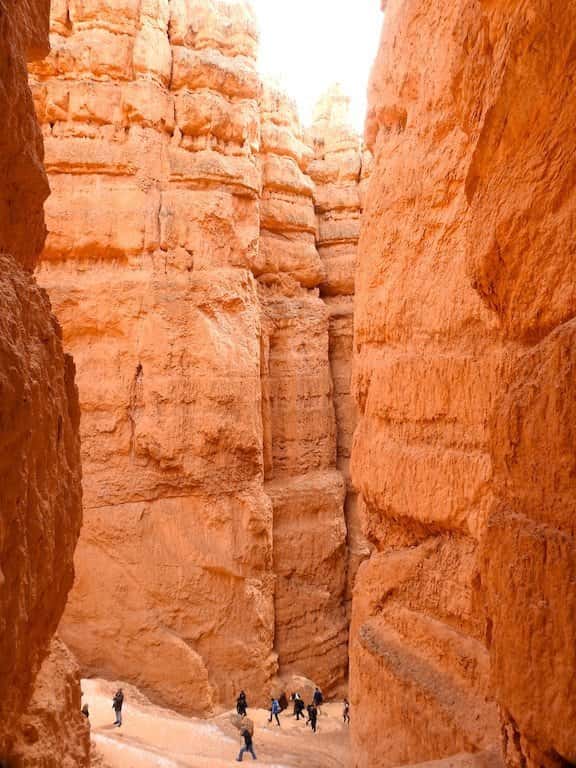
Eventually, this ravine narrows and starts resembling a slot canyon.
This section of Navajo Loop Trail is known as Wall Street, due to the high, vertical cliffs and narrow passages.
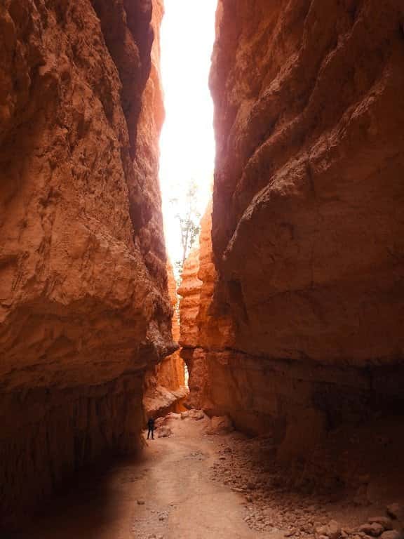
Navajo Loop Trail / Most Scenic Hikes in Bryce Canyon
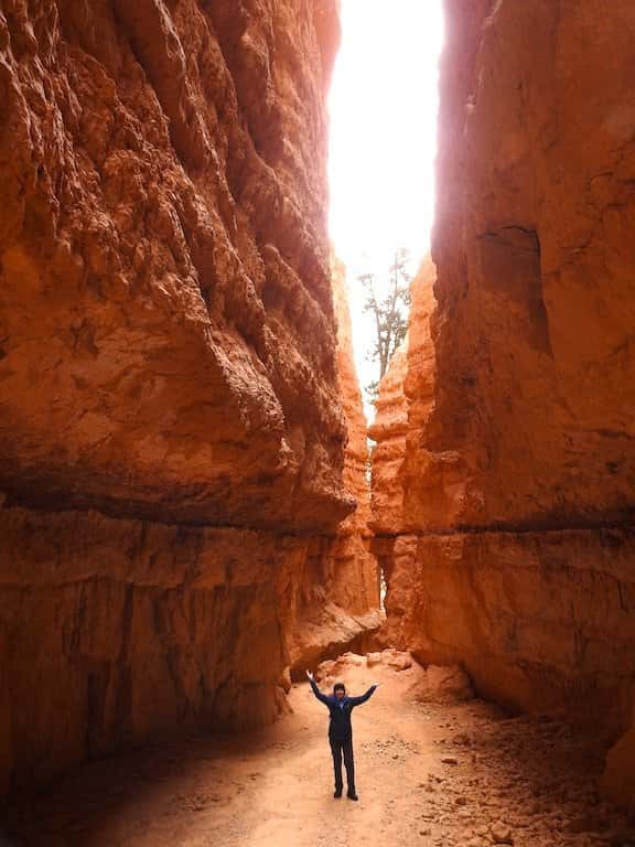
Navajo Loop Trail / Most Scenic Hikes in Bryce Canyon
At this point, you reached the bottom of the main canyon, and looking up at the Bryce Canyon hoodoos from below makes you realize the sheer size of these fantastic rock formations.

Navajo Loop Trail / Most Scenic Hikes in Bryce Canyon
Navajo Loop Trail / Most Scenic Hikes in Bryce Canyon
After about 0.7 miles from the trailhead, you reach a junction with Peek-A-Boo Trail and Queens Garden Trail.
Personally, I like to continue along Queens Garden Trail all the way to Sunrise Point. It is a beautiful hike that takes you along the way to the bottom of the canyon.
It is a great place to see some wildlife as well.

Navajo Loop Trail in Bryce Canyon National Park / Most Scenic Hikes in Bryce Canyon
If you decide to continue your loop, then ahead of you is a steep climb back to the trailhead.
However, along the way, you get to see another famous hoodoo formation in Bryce Canyon National Park known as Two Bridges.
The next famous hoodoo formation on Navajo Loop Trail is Thor’s Hammer.
It is an iconic sight in Bryce Canyon National Park!

Thor’s Hammer in Bryce Canyon National Park / Most Scenic Hikes in Bryce Canyon
Ahead of you is a series of zig-zags that you would have to conquer to get back to the top of the rim.
The switchbacks are fairly steep so take your time and enjoy the spectacular views!
Queens Garden Trail - One of the Best Hikes in Bryce Canyon National Park to See Hoodoos Up Close

Map of Queens Garden Trail in Bryce Canyon National Park / Image Source: NPS / Most Scenic Hikes in Bryce Canyon
- Roundtrip Distance: 1.8 miles (not a loop)
- Trail Location: Sunrise Point
- Time: 1-2 hours
- Elevation Change: 357 feet
- Difficulty: Easy
Hands down, Queens Garden Trail is one of the most popular Bryce Canyon easy hikes that will take you below the rim, and let you meander among the hoodoos and see up-close their intricate carvings.

Queen’s Garden Trail in Bryce Canyon National Park / Most Scenic Hikes in Bryce Canyon
Queens Garden Hike is one of my favorite Bryce trails!
Whenever I visit Bryce Canyon, I usually start with hiking Queens Garden Trail since it is one of the easy and family friendly hikes in Bryce Canyon National Park.
Also, if you are visiting during winter months, it is one of the best hikes in Bryce Canyon winter time.
How to Get to Queens Garden Trail in Bryce Canyon National Park
Queens Garden Trailhead is located at Sunrise Point.
It is super easy to get to Sunrise Point.
Once you get to the Visitor Center, which is about 1 mile past the entrance to the park, continue south for no more than 0.5 miles until you reach a junction.
Be on the lookout for the sign pointing to Sunrise Point. At the junction, turn left and continue for about 0.5 miles until you reach another junction. Next, follow the sign pointing in the direction of Sunset Point/General Store.
Finally, turn left again and continue for about 0.2 miles until you reach the Sunrise Point parking area.
What You Need to Know About Queens Garden Trail in Bryce Canyon National Park
First of all, the trail starts gradually descending along a sloping ridge-line.

Queens Garden Trail in Bryce Canyon National Park / Most Scenic Hikes in Bryce Canyon

Queens Garden Trail / Most Scenic Hikes in Bryce Canyon
Soon enough, you will be passing by several groups of beautiful hoodoo formations. They look awesome up-close.

Hoodoo formations along Queens Garden Trail in Bryce Canyon National Park / Most Scenic Hikes in Bryce Canyon
At about 0.7 miles, the trail passes through a short, artificial tunnel. It is a great place to take some pictures!

Tunnel on Queens Garden Trail in Bryce Canyon National Park / Most Scenic Hikes in Bryce Canyon
Eventually, you will pass by a pinnacle-filled ravine. It is another great place to take some pictures!
By the way, if you enjoy taking pictures, then check out my post: Best Photography Locations in Bryce Canyon

The views along Queens Garden Trail in Bryce Canyon National Park / Most Scenic Hikes in Bryce Canyon
Finally, you encounter a junction with a very short spur trail to a viewpoint of Queens Garden. Make a slight right turn at the junction and follow the signs for Queens Garden.
The garden is a beautiful semi-circular ridge of phantom-like rock spires with elevated rock formation thought to resemble Queen Victoria.

The Queen’s Garden is a beautiful semi-circular ridge of phantom-like rock spires / Most Scenic Hikes in Bryce Canyon
Next, when you are ready, retrace your steps and get back to the main trail.
You have two options at this point.
You can continue hiking or you can simply retrace your steps and get back to Sunrise Point where you started Queens Garden Trail.
If you decide to continue hiking, then right after you retrace your steps to the main trail, there will be a junction to Navajo Loop Trail and Peekaboo Loop Trail.
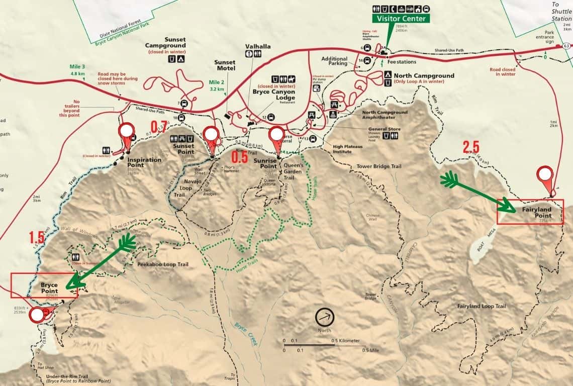
Tower Bridge Trail - One of the Bryce Canyon National Park Best Hikes to See Famous Hoodoos

Map of Tower Bridge Trail in Bryce Canyon National Park
Image Source: NPS
- Roundtrip Distance: 3 miles (not a loop)
- Trail Location: North of Sunrise Point
- Time: 2-3 hours
- Elevation Change: 802 feet
- Difficulty: Moderate
Tower Bridge Trail is one of the top moderate hikes in Bryce Canyon to see some of the most iconic hoodoo formations: China Wall and Tower Bridge!
How to Get to Tower Bridge Trail in Bryce Canyon National Park
Tower Bridge Trailhead is located no more than 0.4 miles north of Sunrise Point.
Once you get to the Visitor Center, which is about 1 mile past the entrance to the park, continue south for no more than 0.5 miles until you reach a junction.
Be on the lookout for the sign pointing to Sunrise Point. At the junction, turn left and continue for about 0.5 miles until you reach another junction. Next, follow the sign pointing in the direction of Sunset Point/General Store.
Finally, turn left again and continue for about 0.2 miles until you reach the Sunrise Point parking area.
What You Need to Know About Tower Bridge Trail in Bryce Canyon National Park
Tower Bridge Trail starts at Sunrise Point and takes you down about 800 feet below the trailhead.
It is one of the best Bryce hiking trails where you will catch sight of a few spectacular rock formations. Specifically, you will see two of my favorites: China Wall and Tower Bridge.
First, you hike down among weather-beaten bristlecone pines. It is amazing how they manage to thrive in these adverse climate conditions.

Tower Bridge Trail in Bryce Canyon National Park / Most Scenic Hikes in Bryce Canyon
Next, the trail takes you to an incredible rock formation called China Wall. It is a huge wall with many windows and towers.
Alternately, follow the trail and once you get to the bottom of the canyon locate a sign pointing both towards Bryce Canyon Fairyland Loop Trail as well as directing you to take a short spur to Tower Bridge.
My suggestion is to take Fairyland Trail for just a bit until you get to a point where you can get a good view of Tower Bridge. Consequently, you will be able to take better pictures from this location without any trees blocking the view.
Next, retrace your steps and get back to the short spur leading to Tower Bridge. At the end of the spur, you will get another view of Tower Bridge.

Hoodoo formation called Tower Bridge / Most Scenic Hikes in Bryce Canyon
If you are up to it, then continue on Fairyland Point Trail.
Otherwise, retrace your steps and get back to Sunrise Point where you started.
Hat Shop Trail - Best Hiking in Bryce Canyon to See Unique Hoodoo Formations

Map of Hat Shop Trail in Bryce Canyon National Park / Image Source: NPS / Most Scenic Hikes in Bryce Canyon
- Roundtrip Distance: 4 miles (not a loop)
- Trail Location: Next to Bryce Point
- Time: 3-4 hours
- Elevation Change: 1075 feet
- Difficulty: Strenuous
Hat Shop Trail is a strenuous trail but you will be rewarded with awesome views of the most unique hoodoos with caprocks balanced on top of them.
How to Get to Hat Shop Trail in Bryce Canyon National Park
From the Bryce Canyon Visitor Center drive 1.5 miles south until you see the sign for Bryce Point.
Next, turn left and follow the road to the Bryce Point parking area.
Unfortunately, parking is very limited, so if you are visiting during summertime then my recommendation is to take the Bryce Canyon shuttle.
What You Need to Know About Hat Shop Trail in Bryce Canyon National Park
Hat Shop Trail is definitely one of a strenuous type of hikes in Bryce Canyon.
The trail takes you down 1,000 feet. However, be prepared for a climb back which is quite steep. Nevertheless, the views on this trail are spectacular.
On a clear day, you can see the vast landscape spreading from Tropic to the north to Paria River Valley and Grand Staircase Escalante National Monument.
At about 2 miles from the trailhead, you will reach the famous Hat Shop, which is a group of narrow, eroded, orange-colored spires. The spires are topped by white-colored boulders delicately balanced at the peak.

The famous Hat Shop along Hat Shop Trail in Bryce Canyon National Park / Most Scenic Hikes in Bryce Canyon
If you are up to it, descend another 400 feet. The trail curves and you can get another view of the formations.
When you are ready to head back, simply retrace your steps and head back to Bryce Point where you started your hike.
Bristlecone Pine Trail - Best Bryce Canyon Hiking to See Bristlecone Pines

Map of Bristlecone Loop Trail in Bryce Canyon National Park / Image Source: NPS / Most Scenic Hikes in Bryce Canyon
- Roundtrip Distance: 1 mile
- Trail Location: Rainbow Point or Yovimpa Point
- Time: 30 min – 1hour
- Elevation Change: 200 feet
- Difficulty: Easy
Bristlecone Loop Trail is one of the easy day hikes in Bryce Canyon National Park where you can see the oldest living things on Earth, the Bristlecone Pines!
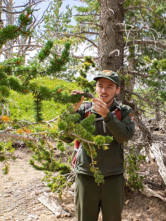
Ranger Mike on Bristlecone Loop Trail / Most Scenic Hikes in Bryce Canyon
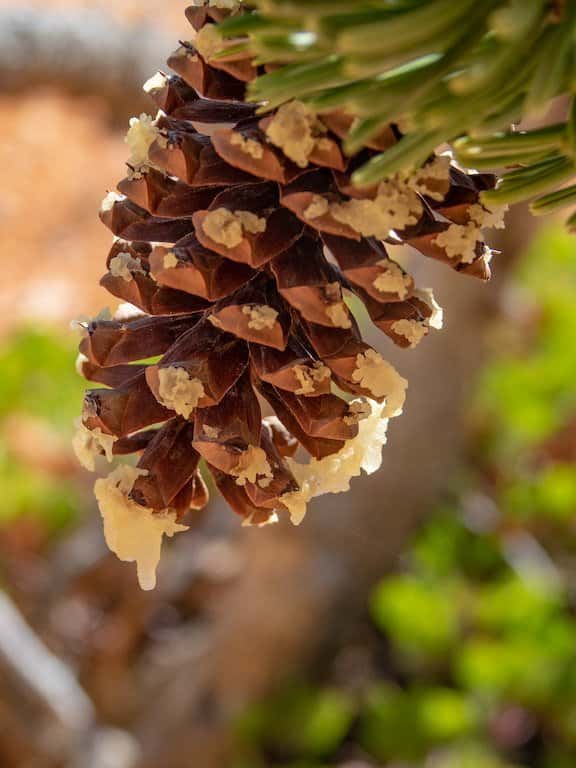
Bristlecone Pine cone covered in sap / Most Scenic Hikes in Bryce Canyon
How to get to Bristlecone Pine Trail in Bryce Canyon
You can start Bristlecone Pine Trail at either Yovimpa Point or Rainbow Point which are located at the very end of Bryce Canyon Scenic Drive.
To get to Yovimpa Point or Rainbow Point take the main road that runs through the park.
The road starts at the entrance to the park and after about one mile passes by the Visitor Center. Continue for about 14 miles until you reach Yovimpa Point. Check out my post and make some stops along the way to catch some more great views of Bryce Canyon.
What You Need to Know About Bristlecone Pine Trail in Bryce Canyon
Bristlecone Loop Trail is one of the easy day hikes in Bryce Canyon National Park.
You can start hiking from either Rainbow Point or Yovimpa Point.
My recommendation is to start at Yovimpa Point. Why? The views just get better as you hike.
First of all, the trail goes through the forest of white fir, Douglas fir, and blue spruce. Next, it meanders to several good viewpoints at the top of the cliffs.

View along Bristlecone Loop Trail in Bryce Canyon National Park / Most Scenic Hikes in Bryce Canyon
The final quarter mile of the path is through a pretty dense forest. It feels great to walk through this section in the summertime since it is cool and shady.
You might be able to find some patches of snow as late as the middle of the summer.
Sheep Creek and Swamp Canyon Loop Trail - The Best Trail to Avoid the Crowds

Map of Sheep Creek and Swamp Canyon Loop Trail / Image Credit: NPS / Most Scenic Hikes in Bryce Canyon
- Roundtrip Distance: 4.3 miles
- Trail Location: Swamp Canyon Viewpoint
- Time: 3-4 hours
- Elevation Change: 647 feet
- Difficulty: Moderate
Of all Bryce Canyon hikes best chill hike in the national park is Sheep Creek and Swamp Canyon Loop Trail. It is not too difficult and not too easy. Just right! On top of that, the views at Swamp Canyon Viewpoint are spectacular!
But, first of all, it is a perfect hike to escape the crowds that swarm the Rim Trail. And, honestly, you will have this trail pretty much to yourself.
Second, if you are hiking in the summertime, this trail provides much-needed shade.
How to get to Sheep Creek and Swamp Canyon Loop Trail in Bryce Canyon
Sheep Creek and Swamp Canyon Loop Trailhead is located along Bryce Canyon Scenic Drive. Specifically, it is located at Swamp anyon Viewpoint.
To get to Swamp Canyon Viewpoint take the main road that runs through the park.
The road starts at the entrance to the park and after about one mile passes by the Visitor Center. Continue for the main road until you reach or about 14 miles until you reach the sign pointing to Swamp Canyon Viewpoint.
Make sure to check out my post about the scenic drive in Bryce Canyon and make some stops along the way to catch some more great views of Bryce Canyon.
What You Need to Know About Sheep Creek and Swamp Canyon Loop Trail in Bryce Canyon National Park
What I like about Sheep Creek and Swamp Canyon Loop Trail is that it starts off at Swamp Canyon Viewpoint and the views are awesome!

Swamp Canyon Viewpoint in Bryce Canyon National Park / Most Scenic Hikes in Bryce Canyon
First of all, the trail goes through a beautiful forested section.
At about 0.2 miles you will reach a junction for Sheep Creek Connecting Trail and Swamp Canyon Connecting Trail. Since it is a loop, you can do it clockwise or counterclockwise.
I like to do this loop clockwise, so if you are ok with it, then at the junction turn left and follow Sheep Creek Connecting Trail.
First, the trail runs through some small valleys wooded with juniper, oak, and ponderosa pine.
At about 2.3 miles from the trailhead, you will reach a junction for Under the Rim Trail. Turn right and continue for Under the Rim trail for about 1.1 miles until you reach another junction for Swamp Canyon Connecting Trail.
Along the way, you will get to enjoy awesome views of the orange-red rock formations of Mud Butte and Swamp Butte.

Sheep Creek and Swamp Canyon Loop Trail in Bryce Canyon National Park / Most Scenic Hikes in Bryce Canyon

Views along Sheep Creek and Swamp Canyon Loop Trail in Bryce Canyon National Park / Most Scenic Hikes in Bryce Canyon
Continue along Swamp Canyon Connecting Trail until you reach Swamp Canyon Viewpoint where you started your hike.
Fairyland Loop Trail - Hands down, one of the best trails in Bryce Canyon

Map of Fairyland Loop Trail in Bryce Canyon National Park / Image Credit: NPS / Most Scenic Hikes in Bryce Canyon
- Roundtrip Distance: 8 miles
- Trail Location: North of Sunrise Point or Fairyland Point
- Time: 4-5 hours
- Elevation Change: 1716 feet
- Difficulty: Strenuous
Fairyland Trail is one of the best hikes in Bryce Canyon National Park that you do not want to miss!
How to get to Fairyland Loop Trail in Bryce Canyon
You can start Fairyland Loop Trail from either north of Sunrise Point (counterclockwise) or from Fairyland Point (clockwise). It is totally up to you. You can choose which direction to start.
However, if you start in a clockwise direction (Fairyland Point) then your hike out of the canyon will be short but steep. On the other hand, if you begin in a counter-clockwise direction (from north of Sunrise Point) then your climb out of the canyon will be longer, however, it will be more gradual.
My recommendation is to do this hike counterclockwise and start north of Sunrise Point!
Here we go! The trailhead head is located no more than 0.4 miles north of Sunrise Point.
Once you get to the Visitor Center, which is about 1 mile past the entrance to the park, continue south for no more than 0.5 miles until you reach a junction.
Be on the lookout for the sign pointing to Sunrise Point. At the junction, turn left and continue for about 0.5 miles until you reach another junction. Next, follow the sign pointing in the direction of Sunset Point Bryce Canyon/General Store.
Finally, turn left again and continue for about 0.2 miles until you reach the Sunrise Point parking area.
What You Need to Know about Fairyland Loop Trail in Bryce Canyon
Fairyland Trail makes a loop through some of the most spectacular landscapes in Bryce Canyon National Park.
It takes you down into the amphitheaters and canyons. You get to walk among the hoodoos and many intricate rock formations.
First of all, you will pass by an incredible rock formation called China Wall. It is a huge wall with many windows and towers.

China Wall along Fairyland Loop Trail in Bryce Canyon National Park / Most Scenic Hikes in Bryce Canyon
At about 1.5 miles from the trailhead you will reach a short spur to a famous rock formation called Tower Bridge.

Tower Bridge along Fairyland Loop Trail in Bryce Canyon National Park / Image Credit: Dan Nevill via Flickr / Most Scenic Hikes in Bryce Canyon
Next, the trail winds through several clusters of hoodoos, all forms of chiseled pinnacles and delicate spires.
Moreover, all around you will be the pink, white, and tan cliffs of Campbell Canyon. It is a beautiful part of the trail where you can take the time and appreciate the whimsy of wind and water which molded these fascinating shapes.

Fairyland Loop Trail in Bryce Canyon National Park / Most Scenic Hikes in Bryce Canyon
The trail slowly gains and loses elevation at this point before dropping down even more to the bottom of the valley.
At about a 4-mile point, the trail starts meandering by Fairyland Canyon and circling around the massive base of Boat Mesa. It gradually starts climbing out of the canyon over a series of switchbacks.
At about 5.5 miles from the trailhead, you reach Fairyland Point.
Ahead of you is a 2.5-mile climb back to the north of Sunrise Point where you started your hike. The views along the way are off the charts!
If you are visiting Bryce National Park in the summertime, then my suggestion is to plan this hike for late afternoon.
First of all, you will avoid the mid-day heat. Second, as you are hiking to Fairyland Point and back up to Sunrise Point, you get to enjoy the spectacular views of a sunset!
Mossy Cave Trail - Fun Trail in Bryce Canyon to See a Waterfall

Map of Mossy Cave Trail in Bryce Canyon National Park / Image Credit: NPS / Most Scenic Hikes in Bryce Canyon
- Roundtrip Distance: 0.8 miles (not a loop)
- Trail Location: North end of the park (4 miles east on Hwy 12)
- Time: 30 min – 1 hour
- Elevation Change: 200 feet
- Difficulty: Easy
Mossy Cave Trail is just a fun hike for the entire family! It is one of Bryce Canyon trail’s best choices for everyone. It easily goes along a stream and takes you to a mossy grotto and a waterfall.
It is a fun hike in the summer because you can take a break and soak your weary feet in the water.
However, check out this hike in the wintertime as well. The grotto with icicles looks quite spectacular in winter!
How to Get to Mossy Cave Trail in Bryce Canyon
Mossy Cave Trail is located at the north end of the park, about 4 miles east on Hwy 12.
Once you leave the Visitor Center, drive about 4 miles north on UT 63 (main park road) north to its junction with Hwy 12.
At the junction turn right and drive 3.5 miles east until you reach a parking area for Mossy Cave Trail.
What You Need to Know about Mossy Cave Trail in Bryce Canyon
Mossy Cave Trail is one of the fun hikes in Bryce Canyon. It meanders alongside a lively stream and takes you all the way to the waterfall and a cave.

Mossy Cave Trail in Bryce Canyon / Most Scenic Hikes in Bryce Canyon
The stream is not natural. It originates from Tropic Ditch, which is an irrigation channel constructed by Mormon settlers between 1890 and 1892 to supply water to Cannonville and Tropic in the dry season when the Paria River stops flowing.
Now, once you find a parking spot, take the trail and start hiking alongside a stream. In about 0.4 miles you will reach a junction.
Turn left at the junction and continue to a mossy cave.
This mossy cave is quite spectacular in the wintertime when the water freezes and forms ice pillars and icicles.
After visiting the cave retrace your steps to the junction and at the junction turn right and continue a bit upstream until you reach a waterfall tumbling down 15 feet over the ledge and forming a small pool. It feels wonderful to take a break here and soak your feet after a long day of hiking.
When you are ready to head back, simply retrace your steps and get back to the parking lot.
Peek-A-Boo Loop Trail - The Most Scenic Hike in Bryce Canyon National Park

Map of Peek-A-Boo Loop Trail in Bryce Canyon National Park / Image Credit: NPS / Most Scenic Hikes in Bryce Canyon
- Roundtrip Distance: 6.0 miles
- Trail Location: Next to Bryce Point
- Time: 3-5 hours
- Elevation Change: 1571 feet
- Difficulty: Strenuous
In my opinion, Peek A Boo Loop Trail is one of the most scenic best hikes in Bryce Canyon National Park. It gets its name from the most unusual arch formations known as windows.
Right from the start of this hike, you will be rewarded with incredible views of Bryce Amphitheater, followed by the famous hoodoo formations known as Wall of Windows, Cathedral, and Fairy Castle.
What you have to keep in mind is that it is a strenuous hike with a steep descent and then a relentless steep ascent back to the rim of Bryce Canyon.
How to Get to Peek-a-Boo Trail in Bryce Canyon National Park
From the Bryce Canyon Visitor Center drive 1.5 miles south until you see the sign for Bryce Point.
Next, turn left and follow the road to the Bryce Point parking area.
Unfortunately, parking is very limited, so if you are visiting during summertime then my recommendation is to take a shuttle.
What You need to know about Peek-A-Boo Trail
First of all, from the parking area, take a path that goes through some wooded area and descends to a junction with Under the Rim Trail.
At the junction turn left and continue towards the Peek-A-Boo Loop.
Now, the views at this point are breathtaking. You will have Bryce Amphitheatre right in front of you with the Boat Mesa in the distance.

The most amazing views of Bryce Canyon National Park form the Peek-A-Boo Trail / Most Scenic Hikes in Bryce Canyon
Pretty soon, the trail goes through a man-made tunnel and it is a perfect spot to take some pictures!

Peek-A-Boo Trail goes through a man-made tunnel / Most Scenic Hikes in Bryce Canyon
At about 1.5 miles from the trailhead, you will reach the junction for Peek-A-Boo Loop.
Now, check the map.
But, from this point, you can do this loop clockwise to counterclockwise. I always do it clockwise. In my opinion, the views are so much better that way.
The first famous hoodoo formation that you are going to see is called the Wall of Windows.

Wall of Windows, Bryce Canyon National Park, Utah / Image Source: David Taylor via Flickr / Most Scenic Hikes in Bryce Canyon
To the northeast of the Wall of Windows, a sea of hoodoos create a structure that is known as the Cathedral.

The Cathedral along Peek-A-Boo Trail in Bryce Canyon / Image Source: David Taylor via Flickr / Most Scenic Hikes in Bryce Canyon
Right after you pass the Cathedral, be prepared for a series of switchbacks.
At 3.2 miles from the trailhead you will reach the junction connecting the Peek-A-Boo trail to Navajo Loop and Queens Garden Trails.
Turn right at the junction and continue on Peek-A-Boo Trail.
The trail will go up and down and take you through some pretty cool hoodoo groups.

Hiking along Peek-A-Boo Trail in Bryce Canyon National Park / Most Scenic Hikes in Bryce Canyon
Along the way, you will still be able to take more pictures of the Cathedral.
At about 4.5 miles from the trailhead you will reach the end of the loop and the hike up to the rim is going to start.
This is the last section of the trail and it is the most demanding part of the hike, so take your time. Make short breaks and enjoy the views.
Riggs Spring Loop Trail - One of the Best Hikes in Bryce Canyon National Park to Escape the Hustle and Bustle of Bryce Amphitheatre

Map of Peek-A-Boo Loop Trail in Bryce Canyon National Park / Image Credit: NPS / Most Scenic Hikes in Bryce Canyon
- Roundtrip Distance: 8.6 miles
- Trail Location: Rainbow Point or Yovimpa Point
- Time:5-6 hours
- Elevation Change: 1675 feet
- Difficulty: Strenuous
Riggs Spring Loop Trail is one of the best hikes in Bryce Canyon National Park that will give you much-needed peace and solitude after the hustle and bustle of Bryce Canyon Amphitheater Region.
You will get to see some splendid views along the way on this trail. In addition, you will hike through sections of pine forest where you get a good chance to spot some wildlife.
How to Get to Riggs Spring Loop Trail in Bryce Canyon National Park
You can start Riggs Spring Loop Trail at either Yovimpa Point or Rainbow Point, both are located at the very end of Bryce Canyon Scenic Drive.
To get to either Yovimpa Point or Rainbow Point take the main road that runs through the park.
The road starts at the entrance to the park and after about one mile passes by the Visitor Center. Continue for about 14 miles until you reach the parking lot for Yovimpa Point and Rainbow Point.
What You Need to Know about Riggs Spring Loop Trail in Bryce Canyon National Park
Since the trail is a loop, you can start hiking clockwise or counterclockwise.
I usually start this trail at Rainbow Point and continue in a clockwise direction.

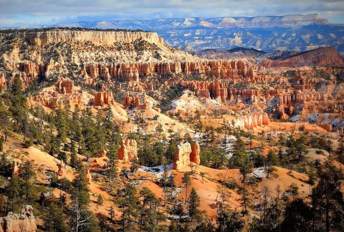
Rainbow Point in Bryce Canyon National Park / Most Scenic Hikes in Bryce Canyon
First of all, follow the signs for Under the Rim Trail for no more than 0.2 miles which is part of Bristlecone Loop Trail.
At the junction, bear right and continue on Riggs Spring Loop Trail.
Ahead of you is a long descent below the Promontory.

Yovimpa Point in Bryce Canyon National Park / Most Scenic Hikes in Bryce Canyon
At first, the trail winds through forested terrain. Shortly after it passes along the edge of the cliff. The views are spectacular here.
Next, the trail descends at a steep grade through a series of switchbacks.
Eventually, you will reach a seasonal stream.
Next, the trail goes through a beautiful forest of ponderosa pines.
At 3.6 miles you’ll pass Corral Hollow Campsite. It is the first backcountry campsite on the loop.
Continue for no more than 1.7 miles until you reach the next campsite called Riggs Spring. This is a perfect spot to take a break because ahead of you is a strenuous unrelenting 1.7-mile section of the hike which will take you back up to Yovimpa Pass where the third campsite is located.
Next, continue for about 1.6 miles until you get back to Rainbow Point where you started.
Bryce Canyon Rim Trail - One of the Best Hikes to Catch the Views of the Amphitheatre
Map of Rim Trail in Bryce Canyon National Park / Image Credit: NPS / Most Scenic Hikes in Bryce Canyon
- Roundtrip Distance: The entire Rim Trail distance is 10.4 miles. You can adjust the distance any way you want.
- Trail Location: Various Access Points
- Time: It will take you 5-6 hours to hike the entire trail, or you can just hike between the best viewpoints (1-2 hours)
- Elevation Change: 1,177 feet if you hike the entire trail
- Difficulty: If you just hike, for example, from Sunrise to Inspiration Point then it is an easy hike with very little elevation change
Hands down, Rim Trail is one of the most spectacular hikes in Bryce Canyon National Park where you can catch the most amazing views!
Honestly, you can hike the entire trail, or you can just hike a small section of this trail.
How to Get to Rim Trail in Bryce Canyon National Park
You can start this hike at many access points.
If you are up to it, then my recommendation is to hike the entire Rim Trail.
The entire trail is 10.4 miles long. It starts at Fairyland Point and goes all the way to Bryce Point.
The elevation change is 1,177 feet and starts to change as you approach Bryce Point.
However, you can hike from Sunrise Point to Inspiration Point. The distance is no more than 1.2 miles from Sunrise Point to Inspiration Point with very little elevation change making it a perfect easy day-hike in the Bryce Canyon.
Now, to get back to the point, how to get to Rim Trail! So, you can start at Sunrise Point. It is super easy to get to Sunrise Point!
Once you get to the Visitor Center, which is about 1 mile past the entrance to the park, continue south for no more than 0.5 miles until you reach a junction.
Be on the lookout for the sign pointing to Sunrise Point. At the junction, turn left and continue for about 0.5 miles until you reach another junction. Next, follow the sign pointing in the direction of Sunset Point/General Store.
Finally, turn left again and continue for about 0.2 miles until you reach the Sunrise Point parking area.
What You Need to Know about Rim Trail in Bryce Canyon National Park
There is no doubt that Rim Trail s the most amazing hike in Bryce Canyon National Park.
The views along the way are just simply off the charts!
View from Rim Trail in Bryce Canyon National Park / Most Scenic Hikes in Bryce Canyon

Hiking along Rim Trail in winter / Most Scenic Hikes in Bryce Canyon
The trail between Sunrise and Sunset points is paved and also so well-worn that portions are wheelchair accessible. However, the rest of the sections have some uneven surfaces which may make wheelchair access to some areas difficult.
There are wooden benches at various points along Rim Trail so take your time, sit down, and enjoy this wondrous scenery.
Intrepid's Tips for Most Scenic Hikes in Bryce Canyon
That is quite a list of the most scenic hikes in Bryce Canyon National Park, right? What if you only have time to do a couple of hikes? No problem! Here are my absolute must-do 2 best hikes in Bryce Canyon National Park:
-
Hands down, Fairyland Trail in Bryce Canyon National Park is one of the most scenic hikes in Bryce Canyon that you do not want to miss! The trail goes through some of the most spectacular landscapes in Bryce Canyon National Park.
-
Second, my favorite top hike in Bryce Canyon National Park is Rim Trail. It offers unsurpassed views of Bryce Canyon National Park! You can do the entire trail, or you can shorten it any way you want.
A trip to Bryce Canyon is perfect paired with a side trip to Zion National Park, Grand-Staircase Escalante National Monument, or Canyonlands, Capitol Reef National Parks. Check out my post: Zion to Bryce Canyon: 3-Day Adventure (with Maps and Photos)
If you are visiting several national parks during your vacation (or during the entire year) and planning to try some awesome national park hikes, you should consider purchasing an annual pass. The cost of the annual pass is $80. However, the annual pass is your ticket to more than 2,000 federal recreation sites, such as national parks, national wildlife refuges, national forests, and grasslands.
Visit More US National Parks:
13 Best Stops on SCENIC DRIVE in Zion National Park (Useful Maps+Practical Tips)
8 Best Stops on SCENIC DRIVE in CAPITOL REEF National Park (Map+ Practical Tips)
8 Things You Can’t Miss on FIRST VISIT to ARCHES National Park
10 Best VIEWPOINTS in GRAND CANYON National Park
Amazing ONE DAY in GRAND CANYON Itinerary (4 Cool Things You Can’t Miss)
Did You Find It Useful?
Why Not Save It to Your Pinterest Board!


Now, It Is Your Turn, I Would Like to Hear Back from You!
Are you planning your trip to Bryce Canyon National Park? Please let me know!
Drop me a quick comment right below!
Click on any of the images below to get inspired and to help you with the planning process with your trip to Bryce Canyon National Park!


Comments:
4 thoughts on “11 Most Scenic HIKES in BRYCE CANYON (Maps+Important Tips)”
Thank you for this extremely detailed and informative post!! Bryce Canyon is on our list of NPs to visit and I’ve already pinned this for later!! Love all of the photos! We have a 3 year old, so the ‘quick facts’ are really helpful for me in determining which of these hikes might be doable for us. Thanks again!
Thank you, Catherine! You will love Bryce Canyon. The views are spectacular!
Fantastic Information. Thank you. Any postings on hikes for dogs?
Hello,
Thank you so much!
Hum… I am not sure about hikes for dogs in Bryce Canyon. I checked Bryce Canyon NP website and it looks like dogs are allowed on paved roads (along all the great viewpoints!) and around campgrounds. Please check it out:
https://www.nps.gov/brca/planyourvisit/pets.htm
Anna