This site uses affiliate links, meaning that if you make a purchase through our links, we may earn an affiliate commission.
The Grand Canyon South Rim is essentially one grand viewing stand. There is nothing like standing at the edge of the rim and soaking it all in the incredible depth, the dramatic vistas, and the fantastic colors of red, rust, and orange.
If you were to unfold a map of the Grand Canyon South Rim, you are going to be overwhelmed by all the viewing opportunities. So, here are my favorite spots along the rim narrowed down to the 10 best viewpoints in Grand Canyon South Rim.
Best Viewpoints in Grand Canyon National Park
- 1. Grand Canyon National Park At-A-Glance
- 2. Map of Grand Canyon
- 3. 10 Best Viewpoints in Grand Canyon National Park
-
- 3.1. Maricopa Point
- 3.2. Hopi Point
- 3.3. Mohave Point
- 3.4. The Abyss Viewpoint
- 3.5. Pima Point
- 3.6. Yavapai Point
- 3.7. Mather Point
- 3.8. Grandview Point
- 3.9. Moran Point
- 3.10. Desert View
- 4. Intrepid Scout's Tips for Best Viewpoints in Grand Canyon
Grand Canyon National Park At-A-Glance
Before diving in, here are a few Grand Canyon National Park highlights to help you plan your trip:
- How to Get to Grand Canyon National Park
The Grand Canyon South Rim is located 60 miles north of Williams, Arizona (via route 64 from Interstate 40) and 80 miles northwest of Flagstaff, Arizona (via route 180). The closest major airport is in Flagstaff, AZ (86 miles from the park). It takes about 1 hour and 20 minutes to reach Grand Canyon from Flagstaff.
In addition, there is limited air service to Grand Canyon Airport
- Best Time to Grand Canyon National Park
Grand Canyon National Park is a great destination to visit at any time of the year. And, it is open 24 hours a day, every day of the year. I have visited Grand Canyon so many times at different times of the year and I have to honestly say that it is an excellent place to see no matter what month you visit!
Spring, specifically – March, April, and May, is the best time to visit the Grand Canyon. The temperatures are mild and range from about 50F to 70F. However, be prepared for occasional showers and even snow. By the same token, you will see fewer crowds and have some serene experiences.
Summer, namely – June, July, and August, is the high season. It is the busiest time of the year. In addition, it is the hottest time of the year with temperatures ranging from 80F at the rim and climbing above 100F below the rim.
Fall, specifically – September, October, and November, is my favorite time to visit the Grand Canyon. The temperatures range from 50F to 70F and the crowds are low!
December, January, and February are good months to visit the Grand Canyon. First of all, the huge tourist crowds are practically gone. However, the temperatures are usually about 40F or below with plenty of snowfall.
- Where to Stay When Visiting Grand Canyon National Park
Hands down, nothing beats staying inside the park! However, accommodations inside the park are very limited and you will need to make reservations way in advance.
My top choice is El Tovar Hotel. It is a historic hotel located directly on the rim of the Grand Canyon. Katchina Lodge and Thunderbird Lodge are my two personal favorites. They both sit along the Rim Trail in the National Landmark Historic District. Above all, they are practically a stone’s throw from the canyon abyss.
If everything is booked inside the park, then the following are some of the places just outside the park that I stayed at before. They are no frills type of accommodations, but they work just fine:
Holiday Inn Express Grand Canyon
Best Western Canyon Squire Inn
The Grand Hotel at the Grand Canyon
- How to Get Around in Grand Canyon National Park
Free shuttle bus service is offered inside the Grand Canyon South Rim National Park. You can hop on and hop off at any of the shuttle stops and use the shuttle bus service as many times as you need. The shuttle is not mandatory, however, it is highly recommended especially during the summer months, since finding a parking spot could be challenging. If you plan on checking out all the viewpoints on Hermit Rest Road, then you will need to either use a shuttle or walk.
Here is a helpful post that explains the shuttle system in detail: Best GRAND CANYON SHUTTLE BUS GUIDE (Useful Maps+Simple Routes+Schedules)
- How Much Does It Cost to Vist Grand Canyon National Park
In order to visit Grand Canyon National Park, you need to purchase a recreational day-use pass, which costs $35 per vehicle and is good for 7 consecutive days. You can buy the pass right at the entrance to the park. If you are visiting several national parks then make sure to get America the Beautiful National Park Pass. This $80 pass is valid for 12 months and gets you into all 400+ national park sites!
- Check Grand Canyon National Park Website for Trail Closures and Changes to Shuttle Operations
It is important that you check Grand Canyon National Park Website for any trail or road closures (usually due to rock slides) prior to going to the park. You can check for updates HERE.
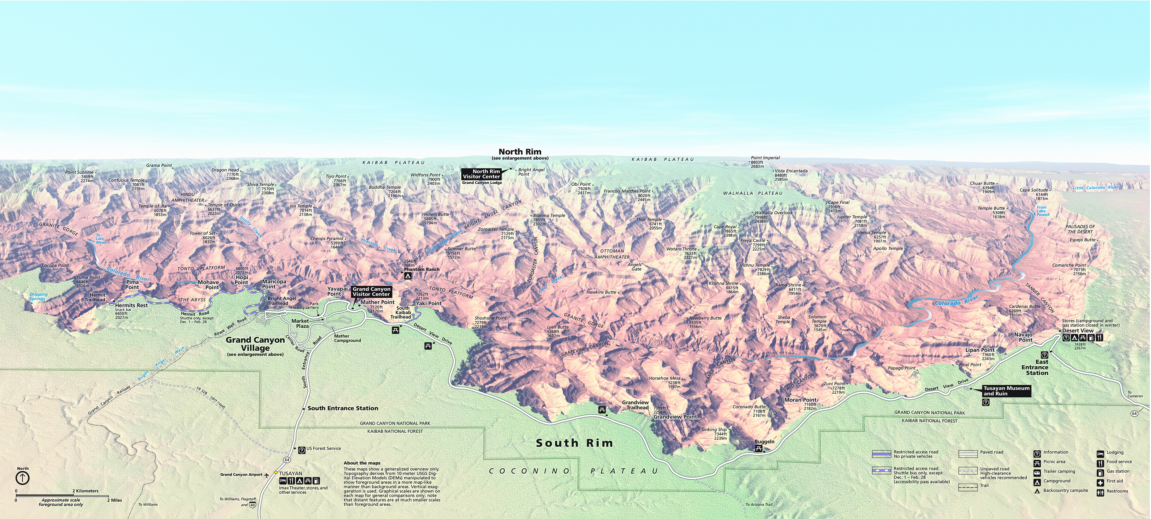
Map of Grand Canyon

Grand Canyon National Park. Image Credit: NPS / Best Viewpoints in Grand Canyon
10 Best Viewpoints in Grand Canyon National Park
My recommendation is to explore the west side of the South Rim along Hermits Rest Drive, then come back to the Grand Canyon Village and check out the main viewpoints there, and finally, finish up with the viewpoints along Desert View Drive.
Maricopa Point
Maricopa Point sits on a narrow promontory extending northeast and then dropping vertically.
The vistas towards the east and west of the canyon are excellent here. In addition, the views extend all the way to the North Rim.
If you look toward the bottom of the picture, you will be able to see an interesting rock formation aptly named the Battleship. California Condors have been known to nest on the Battleship.

Maricopa Point in Grand Canyon / Best Viewpoints in Grand Canyon
Hopi Point
Hopi Point is one of my personal favorites. It is one of the best all-around viewpoints in the Grand Canyon.
Jutting out farther into the Canyon than any other point on the South Rim, Hopi Point offers incredible views.
In addition, it is a great spot to come back to and watch the sunset. You will be able to catch all the reds, rusts, and oranges of the canyon walls as the sun is setting down.

Hopi Point at dusk / Best Viewpoints in Grand Canyon
Moreover, Hopi Point offers excellent views of the stone “temples”.
Temples, in this case, are rock formations rising from the depths of the canyon. If you look at the above photograph all the way to the horizon, you will be able to see the North Rim. Follow the North Rim up to the first indentation.
This is Cape Royal. Cape Royal is a type of temple formed when side-canyon erosion produces peninsula-like projection along the rim.
Afterward, follow the horizon to the next temple. It is Wotan Throne. It was formed by erosion which transformed the peninsula into an island, and eventually, it was separated from the rim.
Finally, let your eyes wander to the last rock formation. It is called Vishnu Temple. Vishnu Temple was formed by further erosion, where the softer rock crumbles and undercuts harder rock.
Mohave Point
If you thought that Hopi Point was good, just wait till you get to Mohave Point.
Not only you will catch the dramatic vistas here, but also you will be able to see some excellent views of the river and rapids below.
In addition, stretching out below the lookout is a rocky promontory known as the Alligator, as it twists toward the river beyond. To the northwest, you can see Hermit Rapid, created when the side of the canyon collapsed into the river.


Mohave Point – looking to the west and east / Best Viewpoints in Grand Canyon
The Abyss Viewpoint
The walk between Mohave and the Abyss is one of the most scenic segments along the rim. The trail sits very close to the edge of the canyon and you will be able to catch some great views down to the canyon.
The Abyss lookout point is located on the very edge of the rim and gives you an almost vertical look down into the canyon below. In the distance, you can see the Colorado River set against the backdrop of the layered rocks.

The Abyss Viewpoint / Best Viewpoints in Grand Canyon
Pima Point
Next is Pima Point. It might be a good idea to get on board the shuttle bus. It is quite a walk from the Abyss to Pima Point. Specifically, it is 2.8 miles from the Abyss to Pima Point.
At Pima Point, you will get one of the best views of the Grand Canyon South Rim and probably the most spectacular view of the Colorado River and rapids below.
The view from Pima Point is particularly spectacular at sunset!

View from Pima Point at sunset / Best Viewpoints in Grand Canyon
You are done exploring the viewpoints along the west side.
At this point, hop on the Red Route/Hermit Rest Road Route shuttle bus eastbound and head back to the Village Route Transfer stop. Once you get to the Village Route Transfer stop, you can hop on the Blue Route/Village Route shuttle bus and get off at the Grand Canyon Visitor Center. Next, follow the signs for Yavapai Point.
Yavapai Point
Yavapai Point sits at the most northerly section of the Grand Canyon South Rim.
Consequently, you will get the best view of the famous three points: Cape Royal, Wotans Throne, and Vishnu Temple. In addition, look down the gorge and onto the serpentine Colorado River.
Mather Point
Mather Point is the busiest viewpoint in the Grand Canyon South Rim. However, it is one of the park’s most spectacular vantage points. The Colorado River is practically below your feet. To the west is Bright Angel Trail, to the east is the South Kaibab Trail, and straight ahead is the North Rim.
the South Kaibab Trail is one of the most visually stunning hikes in the Grand Canyon South Rim. I encourage you to take this hike and get a look at the Canyon below the rim.
Views from Mather Point in Grand Canyon National Park / Best Viewpoints in Grand Canyon National Park
Next, you are going to continue heading east. There are no shuttle buses that operate in this section of the Grand Canyon South Rim.
You are going to jump in your vehicle and drive east on Desert View Drive. The first stop is Grandview Point.
Grandview Point
Grandview Point stands tall at 7,100 feet. It is one of the highest points on the Grand Canyon South Rim. In addition, it is the southernmost point of the canyon.
The views are magnificent here. Grandview Point overlooks the dense forests and the Horseshoe Mesa.

Sunrise at Grandview Point / Best Viewpoints in Grand Canyon
Moran Point
Once you reach Moran Point and glance all around you, you will get a true sense of the vastness of the Grand Canyon South Rim.
Furthermore, directly below Moran Point sits Red Canyon and the colors are just staggering here. The reds, oranges, and rusts glow beautifully, especially in the afternoon sun. To top it off, the sparkling Colorado River finally makes a longer appearance.
Finally, try to find the Sinking Ship, a fascinating geological formation that appears as if it was a sinking vessel against the setting sun.


Moran Point at sunset / Best Viewpoints in Grand Canyon
Moran Point is named after Thomas Moran, a painter who traveled to the Grand Canyon with John Wesley Powell in 1873.
If you like Thomas Moran’s paintings following is a website with a recap of his life and work: Thomas Moran


Moran Point at Sunset / Best Viewpoints in Grand Canyon
Desert View
Desert View is the highest viewpoint on the Grand Canyon South Rim with an elevation of 7,438 feet. Consequently, Desert View offers sweeping views of the Grand Canyon South Rim and the Colorado River.
Perched on the edge of the Grand Canyon South Rim sits Desert View Watchtower. Designed by Mary Colter, Desert View Watchtower combines traditional Southwest architectural styles like Spanish Colonial, Mission, and Native American elements, which we call today Santa Fe style.
Inside you will find a spiral stairway that winds five stories high. Head straight to the top and as you are climbing the stairs look through many windows and see mile upon mile of magnificent views.
By the way, the windows have reflectoscopes, which are viewing instruments that enhance the colors by using black glass.
Once you get to the top, check out the observation deck, which offers great views of the eastern part of the Grand Canyon South Rim.


Desert View Watchtower/ Best Viewpoints in Grand Canyon
Intrepid Scout's Tips for Best Viewpoints in Grand Canyon
The South Rim offers a multitude of stunning viewpoints. It can be easily accessed and enjoyed year-round.
However, have you explored the North Rim yet?
The North Rim is a remote destination, as a result, not a lot of tourists venture out to the North Rim. It is a fantastic choice if you seek a more primeval, natural, quiet, and uncrowded Grand Canyon experience.
You might like: Should You Visit the SOUTH RIM vs NORTH RIM of the Grand Canyon? (7 Things to Know)
Along the South and North Rim, there is the West Rim of the Grand Canyon known for the Grand Canyon Skyway. The West Rim is not a part of the Grand Canyon National Park but is part of a Hualapai sovereign nation. Find out how to visit the West Rim HERE
More Information About Grand Canyon National Park:
9 Best Photography Locations in Grand Canyon (+Useful Photo Tips)
14 Useful Tips for First Visit to Grand Canyon National Park
Grand Canyon Shuttle Bus Guide (Maps+Routes+Schedules
Amazing ONE DAY in GRAND CANYON Itinerary (4 Cool Things You Can’t Miss)
You Might Also Like:
20 Practical ANTELOPE CANYON TIPS for First Visit (IMPORTANT: Read Before Going)
Lower vs Upper Antelope Canyon (Which One Is Voted the Best)
Visit More National Parks:
Did You Find Best Viewpoints in Grand Canyon Useful?
Why Not Save It to Your Pinterest Board!


Now, It Is Your Turn, I Would Like to Hear Back from You!
Are you planning your trip to Grand Canyon National Park?
Please let me know! Drop me a quick comment right below!
Click on any of the images below to get inspired and to help you with the planning process for your trip to Grand Canyon National Park!


Comments:
4 thoughts on “10 Best VIEWPOINTS in GRAND CANYON National Park”
Great!
Thank you, Emily!
Thanks a lot for all this detailed information, this is really helpful!
Hi Johanna,
I am glad you found it useful.
Also, I got your email and thank you for including my link in your article.
Take care!